Key Stage 3: Geography
Curriculum Intent
In Geography lessons at Murray Park we aim to highlight the ‘awe and wonder’ of Geography both locally and around the world. We constantly update our curriculum to ensure our students are up-to-date with all the latest global issues. Our lessons include a range of different teaching and learning styles and we encourage our students to be independent through our project homework tasks. We look to build enquiring minds and open our students’ eyes to the world around us, making them more confident and rounded citizens.
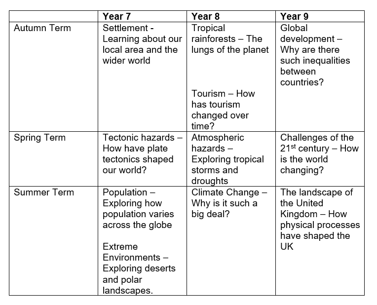
Curriculum overview
Geography lessons at KS3 focus on three main strands as recommended the national curriculum. These include:
Locational knowledge
- extend their locational knowledge and deepen their spatial awareness of the world’s countries, using maps of the world to focus on Africa, Russia, Asia (including China and India), and the Middle East, focusing on their environmental regions, including polar and hot deserts, key physical and human characteristics, countries and major cities
Human and physical geography
- understand, through the use of detailed place-based exemplars at a variety of scales, the key processes in:
- physical geography relating to: geological timescales and plate tectonics; rocks, weathering and soils; weather and climate, including the change in climate from the Ice Age to the present; and glaciation, hydrology and coasts
- human geography relating to: population and urbanisation; international development; economic activity in the primary, secondary, tertiary and quaternary sectors; and the use of natural resources
- understand how human and physical processes interact to influence and change landscapes, environments and the climate; and how human activity relies on the effective functioning of natural systems
Geographical skills and fieldwork
- build on their knowledge of globes, maps and atlases, and apply and develop this knowledge routinely in the classroom and in the field
- interpret Ordnance Survey maps in the classroom and the field, including using grid references and scale, topographical and other thematic mapping, and aerial and satellite photographs
- use Geographical Information Systems (GIS) to view, analyse and interpret places and data
- use fieldwork in contrasting locations to collect, analyse and draw conclusions from geographical data, using multiple sources of increasingly complex information